
How Is Climate Change Shaping Tropical Storm Lala?
The storm will likely make landfall Saturday on the Big Island as a hurricane, the first storm to do so in recent history.
Researchers used to believe that Hawaiʻi island acted “like a rock in the stream,” and the winds controlling the movement of tropical storms had to go around it, according to retired University of Hawaiʻi professor Tom Giambelluca, who now oversees the islands’ Mesonet System of weather stations.
While the island’s geography – with its 13,000-foot central mountains – does play a key role in protecting parts of the island, the reasons large storms have typically been broken up and slowed before they hit Hawaiʻi are varied and complex.
This summer’s supercharged El Niño is largely what’s fueling Tropical Storm Lala, which is expected on Saturday to become the first hurricane to make landfall in Hawai‘i since Iniki in 1992. But scientists say residents should be ready for more storms in the years ahead as the effects of a warming planet take hold in the islands.
“I often tell students that El Niño is like a practice run for climate change,” said Alison Nugent, an associate professor at the UH Department of Atmospheric Science, pointing at how climate change is likely to bring more warm temperatures even when the current El Niño cycle is over.
In the past, relatively cool ocean temperatures and wind shear — or wind that comes from other directions and disrupts the storm — have both historically been important factors in preventing storms from hitting the islands at hurricane strength. A tropical storm becomes a Category 1 hurricane when winds reach 74-95 miles per hour.
Now, as meteorologists have forecast Lala increasing in strength instead of dissipating like the vast majority of storms have in recent decades, it’s raising questions about the impact of climate change. Warmer ocean temperatures are definitely playing a role, Nugent said.
Get the latest news on how the storm affects Hawaiʻi and more:
Hurricanes get their energy from convection, or latent heat. “When you go from a high-energy state of vapor to a lower energy state of liquid, you release heat, and that heat is what fuels hurricanes,” she said. “With climate change, you have warmer oceans, and therefore the potential to get stronger storms.”
Three of the five named storms that have made landfall in Hawai‘i over the last 67 years — Hurricane Dot in 1959, Hurricane Iniki in 1992, Tropical Storm Iselle in 2014, Tropical Storm Darby in 2016 and Tropical Storm Olivia in 2018 — have occurred in the last decade. Climate modeling done in 2016 predicted a significant rise in the number of hurricanes near Hawaiʻi in the coming decades.
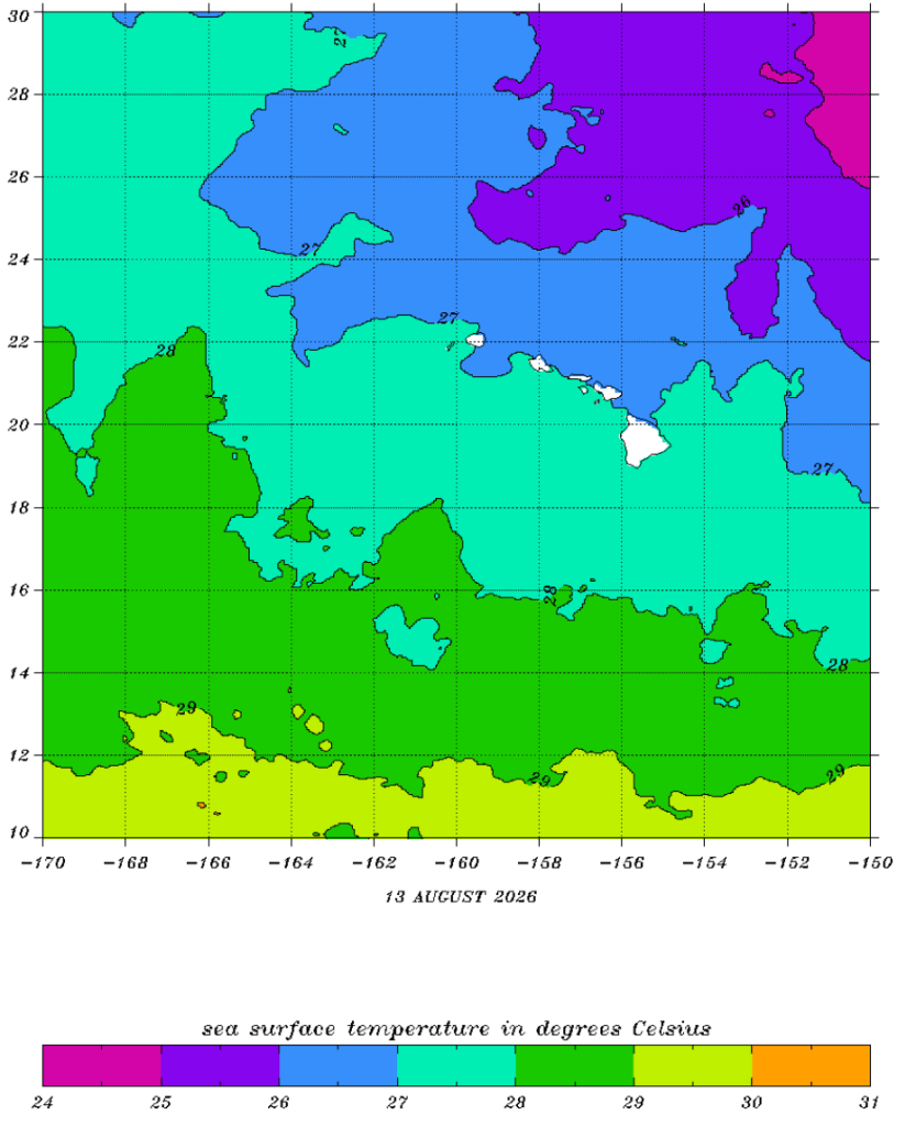
This year, the warmer-than-usual ocean temperature is playing an important role. If the ocean is below 79 degrees Fahrenheit, a hurricane doesn’t form. If the surface of the ocean hits 80 degrees, it’s a different story.
On Thursday, the ocean surface to the south of the islands was between 80.6 and 82.4 degrees Fahrenheit, or 27 and 28 degrees Celsius.
Exactly how climate change is fueling Lala isn’t entirely clear, however. That’s in part because El Niño — the ocean’s natural warming pattern, which occurs every four to seven years — is also causing significantly warmer temperatures this year. And while some scientists say there’s clear evidence that the climate’s overall warming patterns are supercharging El Niño, that’s still being debated within the scientific community.
“The relationship between En Niño and climate change is not well-documented or understood,” said Steven Businger, a professor and former chair of UH’s Atmospheric Sciences Department.

Most of the changes to sea surface temperatures are occurring and being driven by boundary currents that are feeding warmer sea surface temperatures to the middle latitudes, at around 45 degrees north, Businger said. Hawaiʻi is located around 20 degrees north.
“If you look at sea surface temperature change over the last few decades, Hawai‘i is in a special pocket of very little change,” he added.
If Lala does cause significant damage, scientists may conduct an attribution study. Groups like World Weather Attribution release rapid attribution studies within days of storms, floods and other wide-scale climate disasters, assessing whether and to what extent human-caused climate change altered the likelihood or intensity of those events.
Whatever researchers find, Businger said the warm ocean surface temperatures will continue through this winter.
“This is the year for storms,” he said. “The other thing to recognize is that warm water sticks around for a while — so next summer will also have a potential to create problems.”
